


Washington Precinct 05-001, Washington County, Maryland
About
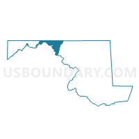
Outline

Summary
| Unique Area Identifier | 593204 |
| Name | Washington Precinct 05-001 |
| County | Washington County |
| State | Maryland |
| Area (square miles) | 53.35 |
| Land Area (square miles) | 52.03 |
| Water Area (square miles) | 1.32 |
| % of Land Area | 97.53 |
| % of Water Area | 2.47 |
| Latitude of the Internal Point | 39.68623130 |
| Longtitude of the Internal Point | -78.23956480 |
Maps


Graphs
Select a template below for downloading or customizing gragh for Washington Precinct 05-001, Washington County, Maryland


Neighbors
Neighoring Voting District (by Name) Neighboring Voting District on the Map
- Voting District 13, Morgan County, WV
- Voting District 2, Morgan County, WV
- Voting District 6, Morgan County, WV
- Allegany Precinct 01-000, Allegany County, MD
- BETHEL TWP Voting District, Fulton County, PA
- THOMPSON TWP Voting District, Fulton County, PA
- UNION TWP Voting District, Fulton County, PA
- WARREN TWP Voting District, Franklin County, PA
- Washington Precinct 15-001, Washington County, MD
Top 10 Neighboring County Subdivision (by Population) Neighboring County Subdivision on the Map
- District 3, Morgan County, WV (6,200)
- District 1, Morgan County, WV (4,966)
- District 5, Hancock, Washington County, MD (3,381)
- District 15, Indian Spring, Washington County, MD (2,019)
- Bethel township, Fulton County, PA (1,508)
- Thompson township, Fulton County, PA (1,098)
- District 1, Orleans, Allegany County, MD (936)
- Union township, Fulton County, PA (706)
- Warren township, Franklin County, PA (369)
Top 10 Neighboring Place (by Population) Neighboring Place on the Map
Top 10 Neighboring Unified School District (by Population) Neighboring Unified School District on the Map
- Washington County Public Schools, MD (147,430)
- Allegany County Public Schools, MD (75,087)
- Tuscarora School District, PA (18,407)
- Morgan County School District, WV (17,541)
- Southern Fulton School District, PA (5,594)
Top 10 Neighboring State Legislative District Lower Chamber (by Population) Neighboring State Legislative District Lower Chamber on the Map
- State House District 90, PA (70,210)
- State House District 78, PA (60,809)
- State Legislative Subdistrict 1C, MD (39,335)
- State House District 51, WV (20,765)
Top 10 Neighboring State Legislative District Upper Chamber (by Population) Neighboring State Legislative District Upper Chamber on the Map
- State Senate District 33, PA (280,954)
- State Senate District 30, PA (239,492)
- State Senate District 15, WV (122,121)
- State Senate District 1, MD (118,930)
Top 10 Neighboring 111th Congressional District (by Population) Neighboring 111th Congressional District on the Map
- Congressional District 6, MD (738,943)
- Congressional District 9, PA (666,810)
- Congressional District 2, WV (648,186)
Top 10 Neighboring Census Tract (by Population) Neighboring Census Tract on the Map
- Census Tract 116, Franklin County, PA (6,485)
- Census Tract 9707, Morgan County, WV (6,355)
- Census Tract 106, Washington County, MD (5,033)
- Census Tract 9603, Fulton County, PA (4,760)
- Census Tract 1, Allegany County, MD (3,718)
- Census Tract 9708, Morgan County, WV (3,569)
- Census Tract 107, Washington County, MD (3,447)
- Census Tract 9709, Morgan County, WV (2,562)
Top 10 Neighboring 5-Digit ZIP Code Tabulation Area (by Population) Neighboring 5-Digit ZIP Code Tabulation Area on the Map
- 25411, WV (12,633)
- 17236, PA (8,895)
- 21750, MD (3,766)
- 17267, PA (2,810)
- 17238, PA (1,794)
- 25422, WV (1,700)
- 21766, MD (700)